Tjoritja / West MacDonnell National Park
159 km away
The West MacDonnell Ranges run due west from Alice Springs in the centre of Australia, and the park's first gorge,…
8 tickets & tours
Canyon Park · Northern Territory · Australia
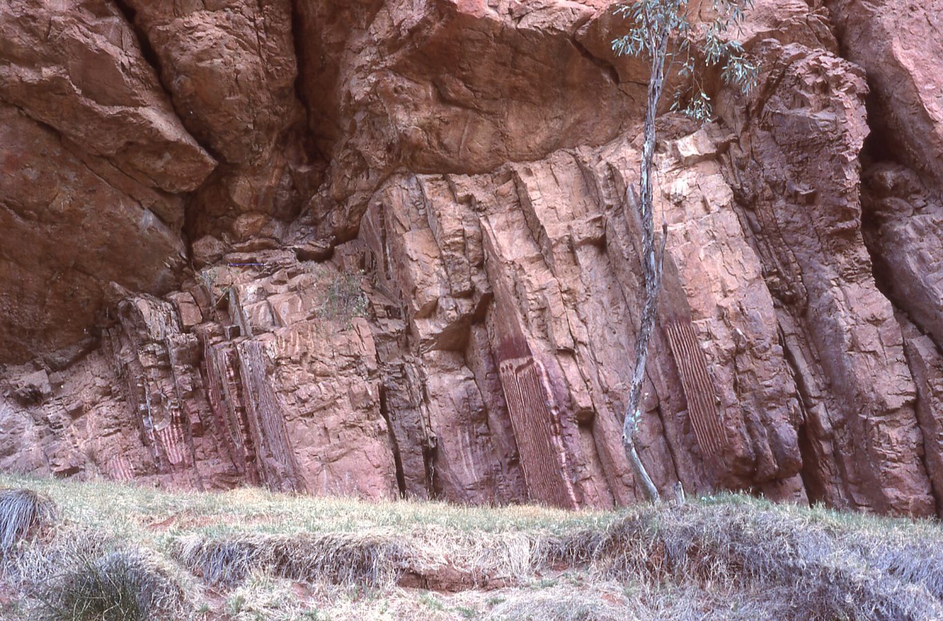
Photo: Sardaka, CC BY-SA 4.0
Emily Gap and Jessie Gap are two narrow clefts in the long red wall of the East MacDonnell Ranges, in the very centre of Australia, and they are the first stops on the Ross Highway, the sealed road that runs eastwards from Alice Springs, lying only ten and seventeen kilometres from the town, so that they can be visited in a couple of hours by car, by bicycle or as the beginning of a day's drive to the more distant gorges of the eastern ranges. Alice Springs is reached by air from all the Australian capitals, by the Ghan train, or by the Stuart Highway, fifteen hundred kilometres from either Darwin or Adelaide. The park is free, open at all times, and entered directly from the highway, with a small car park, picnic tables, shade shelters and toilets at each gap, and no camping.
At each, a walk of a few minutes along a dry, sandy creek bed, shaded by river red gums, leads into the gap itself, between orange cliffs a few dozen metres apart. At Emily Gap, the more important of the two, the rock paintings for which the park is known lie on the eastern wall, a short way in; a waterhole sometimes fills the floor of the gap after rain, and one may then have to wade or turn back. Jessie Gap is similar and quieter, with a smaller group of paintings. Since 2021 the two have been joined by the Yeperenye trail, a well-made walking and cycling path of a little over seven kilometres each way along the foot and the low crest of the range, with shelters and interpretive signs, which takes about two and a half hours on foot in one direction, so that a car at each end, or a return the same way, is needed. There is no drinking water.
Live prices from GetYourGuide for tours whose route includes this park. Free cancellation on most of them.
The two gaps were protected as a nature park in the 1970s and the park was given its present double name in recognition of its Aboriginal significance, Yeperenye being the word of the Arrernte people for a kind of caterpillar. To the Eastern and Central Arrernte, the traditional owners of the Alice Springs district, which they call Mparntwe, this is one of the most sacred places in their country. In their tradition the landscape of Alice Springs was made in the creative era by ancestral caterpillar beings of three kinds, the Yeperenye, the Ntyarlke and the Utnerrengatye, who originated at Emily Gap, which is called Anthwerrke, travelled across the country, formed the ridges and gaps of the ranges by their movements and their battles with an enemy, the stink bug people, and finally lay down to become features of the land; the long, humped ridges of the MacDonnell Ranges, seen from the air, do look remarkably like caterpillars crawling across the plain. The real caterpillars, those of a hawk moth, which appear in numbers on a low creeping vine after rain, were a food, and their increase was secured by ceremonies held at this place. The painting at Emily Gap, on a tall, smooth face of orange rock, is unlike the rock art that most visitors expect: it consists of bold vertical stripes in red ochre and white lime, several metres high, with smaller designs, which represent the caterpillar ancestors.
It is a registered sacred site, protected by law, and visitors are asked to look, to keep back from the rock, not to touch, and to respect the signs concerning photography. The Yeperenye trail is a landmark of another sort: it was proposed, designed and largely paid for by the traditional owners themselves, out of the rent that they receive for the lease of their parks to the Northern Territory, and built by Aboriginal workers, the first public trail in the Territory to be funded in that way. The origin of the English names, given by the surveyors of the overland telegraph line in the 1870s, is not certainly known. The ranges are of quartzite and sandstone some eight hundred million years old and more, folded on end, through which ancient rivers, older than the present ranges, maintained their courses as the land rose, cutting the gaps; the creeks now flow only for a few days after heavy rain. River red gums line the creek beds, white-trunked ghost gums cling to the cliffs, and the slopes carry spinifex, mulga, native figs and, after rain, a flush of wild flowers. Black-footed rock wallabies live on the ledges and come out at dusk, euros, the hill kangaroos, rest in the shade, and the birds include the spinifex pigeon, the zebra finch, the painted finch, the grey-crowned babbler, the Australian ringneck parrot and the wedge-tailed eagle, with the perentie, the largest lizard of the continent, and other monitors and dragons on the rocks.
The park is open all year. The cool months, from April to September, are the time for central Australia, with cloudless days of 18 to 27 degrees and cold nights, sometimes below freezing in June and July; this is when the trail should be walked, and the first and last hours of daylight, when the cliffs glow and the wallabies are about, are the best. From October to March the heat is severe, often above 40 degrees, the flies are persistent, and walking should be confined to the early morning, with at least a litre of water for each hour;
summer storms occasionally send the creeks down in flood and close the highway's causeways for a day or two. Carry all the water needed, a hat and sunscreen, and keep to the paths. Allow one to three hours. Corroboree Rock is forty-five kilometres from Alice Springs on the same road, Trephina Gorge eighty-five, and the old goldfield of Arltunga a hundred and ten.
159 km away
The West MacDonnell Ranges run due west from Alice Springs in the centre of Australia, and the park's first gorge,…
8 tickets & tours
242 km away
Watarrka National Park, in the desert of the southern Northern Territory, contains Kings Canyon, a great cleft of red…
11 tickets & tours
347 km away
Uluru stands in the middle of Australia, 450 kilometres by road from Alice Springs, and nearly everyone stays at…
10 tickets & tours
Yes. GetYourGuide sells tickets and guided tours whose route includes Yeperenye / Emily and Jessie Gaps Nature Park; live prices are shown on this page.
The park is open all year.
Allow one to three hours.
Yeperenye / Emily and Jessie Gaps Nature Park covers 12.1 km².
Yeperenye / Emily and Jessie Gaps Nature Park was established in 2009.
Yeperenye / Emily and Jessie Gaps Nature Park is in Northern Territory, Australia. The map on this page shows the exact spot.
Northern Territory, Australia
Watarrka National Park, in the desert of the southern Northern Territory, contains Kings Canyon, a great cleft of red…
11 tickets & tours
Northern Territory, Australia
Uluru stands in the middle of Australia, 450 kilometres by road from Alice Springs, and nearly everyone stays at…
10 tickets & tours
Northern Territory, Australia
Kakadu lies in the tropical north of Australia, its edge 150 kilometres and its centre at Jabiru 250 kilometres east of…
9 tickets & tours
Northern Territory, Australia
The West MacDonnell Ranges run due west from Alice Springs in the centre of Australia, and the park's first gorge,…
8 tickets & tours
Northern Territory, Australia
Litchfield is the waterfall park an hour and a half south of Darwin, by way of the small town of Batchelor, and…
7 tickets & tours
Northern Territory, Australia
Nitmiluk, formerly called Katherine Gorge, is a chain of thirteen sandstone gorges cut by the Katherine river in the…
2 tickets & tours