Arrecifes de Cozumel National Park
Mexico
The reefs of Cozumel, off the Caribbean coast of the Yucatan peninsula of Mexico, are among the most celebrated diving…
75 tickets & tours
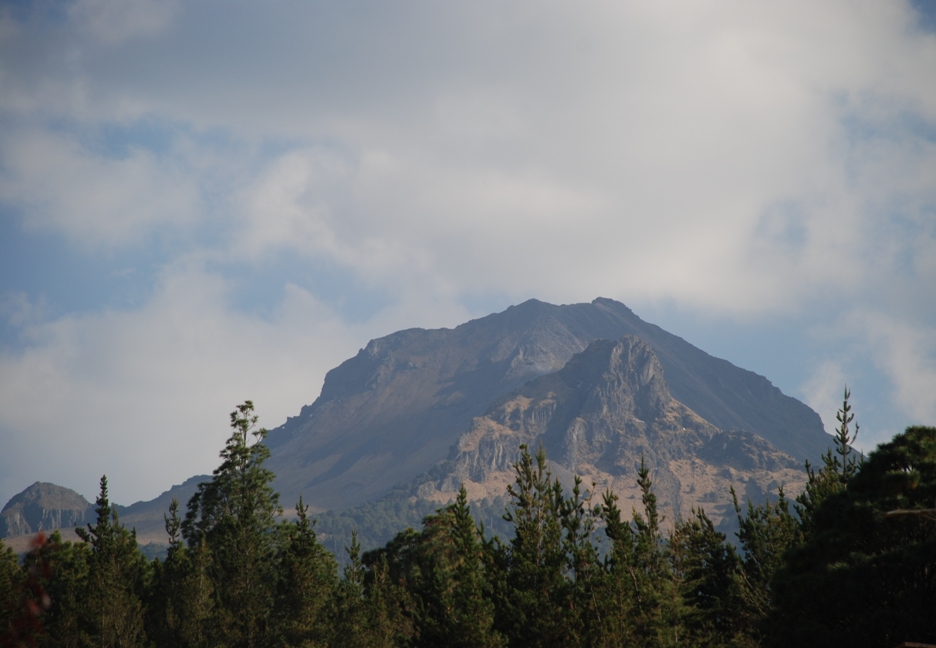
Photo: Elelicht, CC BY-SA 3.0
La Malinche is the broad, isolated, extinct volcano that stands between the cities of Puebla and Tlaxcala, east of Mexico City, the sixth highest mountain in Mexico, and it is known to every Mexican mountaineer as the training peak: a summit of nearly 4,500 metres that can be reached and descended in a single day on foot, with no snow, ice or technical difficulty in normal conditions, and therefore the standard acclimatisation climb before attempting the glaciated giants, Pico de Orizaba and Iztaccíhuatl. The usual starting point is the Centro Vacacional IMSS Malintzi, a holiday centre of the social security institute at about 3,100 metres on the northern side, reached by a paved road from the towns of Apizaco or Huamantla in Tlaxcala state, about an hour from Puebla and two and a half from Mexico City;
it has cabins with fireplaces, a campground and a restaurant, and sleeping there the night before is the best preparation. There is no entrance fee for the mountain. From the barrier the route follows a paved and then dirt road through pine forest, crossing its hairpins by a direct path, emerges above the tree line at about 3,900 metres, and climbs a long, steep slope of sand and loose scree to the summit ridge and a final easy scramble over boulders to the top: about twelve kilometres return, 1,300 metres of ascent, and six to eight hours for most people. The guided day hikes from Puebla and Mexico City supply transport, a guide and lunch, leaving at four or five in the morning, which is worth it for solo travellers, since the forest section has a history of occasional robberies and groups are safer.
Live dates and prices from GetYourGuide. Free cancellation on most tickets.
The national park was decreed in 1938 by President Lázaro Cárdenas and covers about 458 square kilometres, two thirds of it in the state of Tlaxcala and the rest in Puebla, a forest island surrounded by one of the most densely populated farming regions in Mexico. The volcano, 4,461 metres high according to the national survey, is part of the Trans-Mexican volcanic belt, an old, deeply eroded stratovolcano that has not erupted for about three thousand years, with a wide, gently sloping base scored by ravines and a rocky summit crest from which a great bite, a glacial cirque, has been taken on the north-eastern side. To the Tlaxcaltecs, who lived at its foot, it was Matlalcuéyetl, she of the blue skirt, a goddess of rain, water and song, the consort of Tláloc, and offerings were made on its slopes; the Spaniards renamed it for Malintzin, La Malinche, the Nahua woman who was interpreter, adviser and companion to Hernán Cortés and mother of his son, a figure whom Mexicans have regarded by turns as a traitor and as the mother of the mestizo nation.
It was the Tlaxcaltecs, of course, who allied themselves with Cortés against the Aztecs. The slopes are covered with forests of pine, of several species including the Hartweg's pine that forms the tree line, fir, the sacred oyamel, oak and alder, giving way above to zacatonal, tussock grassland, and then to bare sand and rock. From the top, in the clear air of a winter morning, the view is one of the finest in Mexico: Popocatépetl, usually smoking, and Iztaccíhuatl to the west, Pico de Orizaba and the Cofre de Perote to the east, and the checkerboard of fields, villages and church domes of the Puebla-Tlaxcala valley below. White-tailed deer, bobcats, coyotes, the volcano rabbit's relatives and the endemic Malinche salamander of the high streams survive, though the forest has suffered from illegal logging, fires and an infestation of bark beetles.
The mountain can be climbed all year. The dry season, from November to April, is the best, with clear, cold mornings, frost and occasional snow on the upper slopes from December to February, when the summit ridge can be icy and crampons useful; in the rainy season, from June to October, the mornings are generally fine and thunderstorms, with lightning and hail, build from midday, so that an early start and a turn-round time of noon are essential.
The altitude is the real difficulty: spend at least two or three days in Mexico City or Puebla, both above 2,100 metres, first, carry warm and windproof clothing, two to three litres of water and sun protection, and turn back if headache or nausea come on. Allow a full day. Tlaxcala's colonial centre and the murals of its government palace, Huamantla, famous for its carpets of flowers in August, the pyramid of Cholula and Puebla are all within an hour.
Yes. GetYourGuide lists 3 tickets and tours for La Malinche National Park, with live dates and prices and free cancellation on most of them.
There is no entrance fee for the mountain.
There is no entrance fee for the mountain.
La Malinche National Park covers 461 km².
La Malinche National Park was established in 1938.
La Malinche National Park is in Mexico. The map on this page shows the exact spot.
Mexico
The reefs of Cozumel, off the Caribbean coast of the Yucatan peninsula of Mexico, are among the most celebrated diving…
75 tickets & tours
Mexico
Puerto Morelos is the fishing village between Cancún and Playa del Carmen whose reef, part of the Mesoamerican barrier…
45 tickets & tours
Mexico
Ría Lagartos is the flamingo lagoon on the northern tip of Yucatán, two hours from Valladolid and three from Cancún or…
28 tickets & tours
Mexico
Los Arcos are the granite islets with the arches off Mismaloya, twelve kilometres south of Puerto Vallarta, and the…
16 tickets & tours
Mexico
Cabo Pulmo is a village of a few hundred people on the East Cape of Baja California Sur, on the Gulf of California,…
8 tickets & tours
Mexico
Iztaccihuatl and Popocatepetl, the second and third highest mountains of Mexico, stand side by side on the eastern rim…
6 tickets & tours


