
Queen Elizabeth National Park
Uganda
Queen Elizabeth is Uganda's most visited savanna park, six to seven hours by road from Kampala or Entebbe, and it…
37 tickets & tours
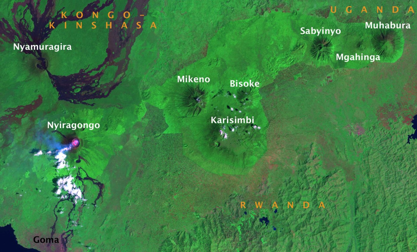
Photo: Per A.J. Andersson, CC BY-SA 3.0
Mgahinga is Uganda's smallest national park, in the extreme south-western corner of the country above the town of Kisoro, nine to ten hours by road from Kampala, and, more usefully, three to four from Kigali in Rwanda by the Cyanika border, fifteen minutes from Kisoro; light aircraft also fly to Kisoro's airstrip from Entebbe. It is Uganda's share of the Virunga volcanoes, and it offers four quite distinct activities, all starting from the Ntebeko visitor centre, fourteen kilometres up a rough road from the town. Gorilla tracking: the park has one habituated family, Nyakagezi, which in the past wandered across into Rwanda and Congo for months at a time but has stayed on the Ugandan side for more than a decade;
only eight permits a day are sold, by the Uganda Wildlife Authority at 800 dollars for foreign non-residents, the same as at Bwindi, and the forest here is more open and the walking generally easier than Bwindi's. Golden monkey tracking, in the bamboo zone, costs a fraction of that, is rarely sold out, and gives an hour with a troop of these endangered, handsome and hyperactive monkeys, found only in the Virungas. Volcano climbs: each of the three peaks is a separate, long day's hike with an armed ranger, for a modest fee. And the Batwa Trail, a half-day walk led by Batwa guides through the forest from which their people were evicted. The three- and four-day tours from Kigali or Kampala include the permit, transport and lodging in Kisoro or at the lodges by the park gate, and one-day trips run from Lake Bunyonyi and Kisoro.
Live dates and prices from GetYourGuide. Free cancellation on most tickets.
The park was gazetted in 1991, on land that had been a gorilla sanctuary since 1930, and covers only 33.7 square kilometres, the northern slopes of three extinct volcanoes whose summits mark the frontier: Muhabura, the guide, 4,127 metres, a steep cone with a small crater lake on top; Gahinga, 3,474 metres, the smallest, whose name, meaning a pile of stones, is that of the cairns of lava rocks that local farmers clear from their fields, with a swampy crater; and Sabyinyo, the old man's teeth, 3,669 metres, an older, deeply eroded mountain with a jagged crown, on whose highest peak, reached by a series of alarming wooden ladders, a walker stands in Uganda, Rwanda and the Democratic Republic of Congo at once. The park is contiguous with Rwanda's Volcanoes park and Congo's Virunga park, the three forming a single conservation area of 434 square kilometres which holds about 600 of the world's thousand or so mountain gorillas, the rest living in Bwindi.
The vegetation rises in belts: regenerating montane woodland on former farmland at the bottom, from which settlers were moved out in 1992, then a broad zone of bamboo, the gorillas' favourite food in the rainy seasons when the shoots come up and the domain of the golden monkey, then hagenia and hypericum forest, then giant heathers, and above 3,300 metres an Afro-alpine moorland of giant lobelias and groundsels. Buffalo and forest elephants are present, which is the reason for the armed escort, along with bushbuck, black-fronted duikers, giant forest hogs and golden cats; among 180 bird species are the Rwenzori turaco and a dozen other Albertine Rift endemics. The Batwa, forest hunter-gatherers and the region's first people, lost their home without compensation when the park was made; on the trail that bears their name they show how they made fire, hunted, gathered honey and medicine, and they sing in the Garama cave, a lava tube 342 metres long that was their king's council chamber and refuge.
Activities start at the Ntebeko centre at about 7.30 in the morning, every day. The drier months, from June to August and from December to February, are the best for the volcano climbs, which are miserable and viewless in rain and cloud, and the easiest underfoot for tracking;
in the rainy seasons, March to May and September to November, the gorillas and golden monkeys feed low on bamboo shoots and treks can be short, permits are easy to find and the lodges cheaper. The nights are cold at 2,300 metres and the summits near freezing. Allow two to three days. Kisoro, Lake Mutanda and Lake Bunyonyi are close by, Bwindi's southern trailheads an hour or two north, and Rwanda's Volcanoes park just across the border.
Yes. GetYourGuide lists 5 tickets and tours for Mgahinga Gorilla National Park, with live dates and prices and free cancellation on most of them.
Allow two to three days.
Mgahinga Gorilla National Park covers 33.7 km².
Mgahinga Gorilla National Park was established in 1991.
Mgahinga Gorilla National Park is in Uganda. The map on this page shows the exact spot.
Uganda
Queen Elizabeth is Uganda's most visited savanna park, six to seven hours by road from Kampala or Entebbe, and it…
37 tickets & tours
Uganda
Murchison Falls is Uganda's largest park and the one closest to Kampala for a proper savanna safari, about five…
35 tickets & tours
Uganda
Lake Mburo is the small savanna park on the Kampala–Mbarara road, about four hours from the capital, and its position…
31 tickets & tours
Uganda
Kibale is the chimpanzee forest of western Uganda, five hours from Kampala or Entebbe and forty minutes from Fort…
15 tickets & tours
Uganda
Bwindi holds about half of the world's mountain gorillas, in the far south-west of Uganda, eight to ten hours by…
8 tickets & tours
Uganda
The Rwenzori are the snow-capped Mountains of the Moon on Uganda's border with Congo, above the town of Kasese,…
8 tickets & tours


