Thingvellir National Park
Iceland
Thingvellir lies forty-five kilometres, about three quarters of an hour by a good road, north-east of Reykjavik, and it…
176 tickets & tours
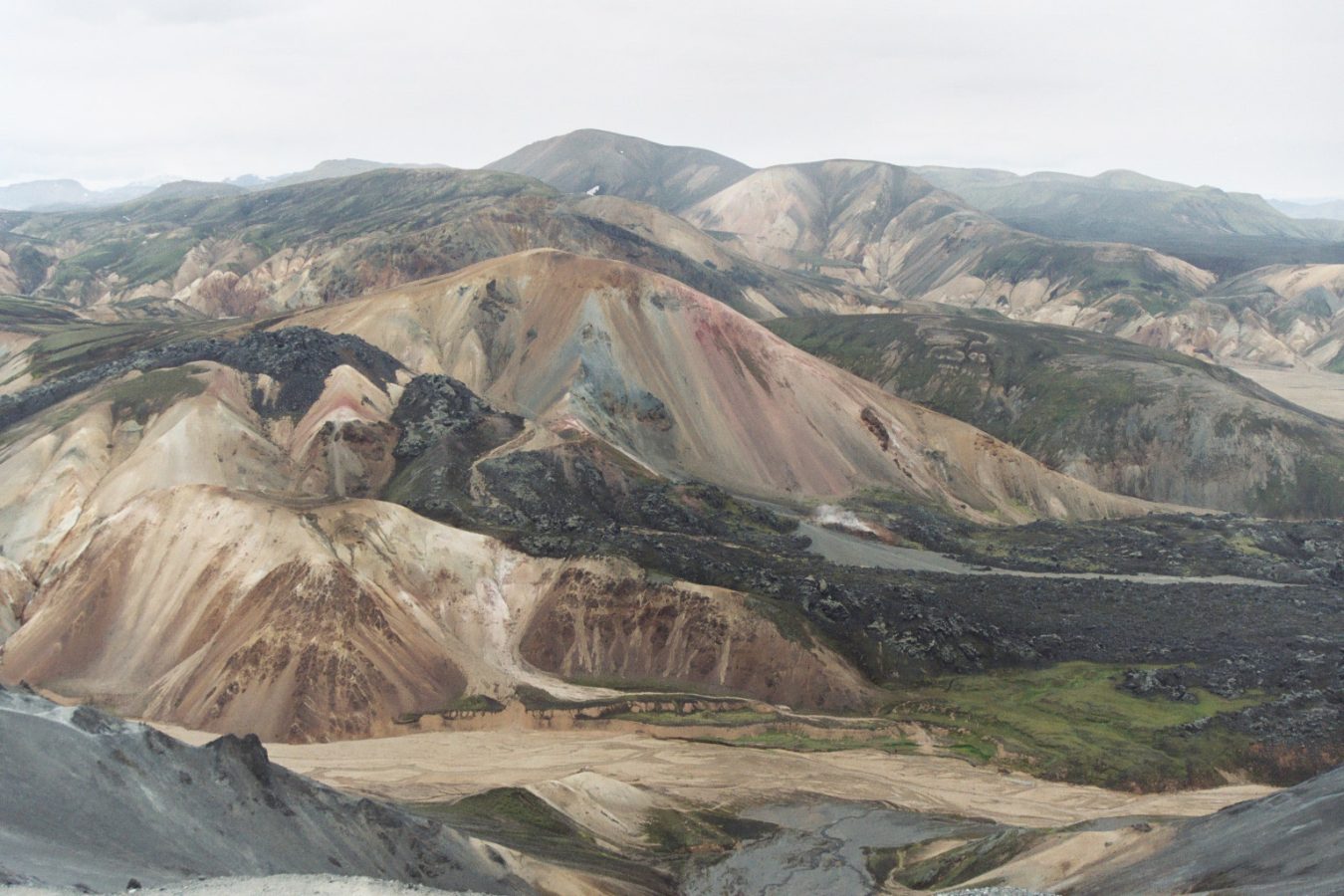
Photo: The original uploader was Nojhan at French Wikipedia., CC BY-SA 1.0
Fjallabak is a reserve in the uninhabited southern highlands of Iceland, a wilderness of multicoloured rhyolite mountains, black lava, steaming vents and crater lakes, and nearly everyone who goes there is bound for one place within it, Landmannalaugar, the hot pools of the people of Land, which is both the most celebrated beauty spot of the Icelandic interior and the start of the country's most famous long-distance walk. It lies about 190 kilometres from Reykjavik, and the last forty to sixty of them, by whichever of three routes, are on mountain roads, rough, unsurfaced tracks that are open only in summer and are legally restricted to four-wheel-drive vehicles: the northern approach, from the power stations near Hrauneyjar, is the easiest and has no river to ford until the campsite itself, where ordinary cars are left on the near bank, while the western and southern approaches involve a number of fords, some of them deep after rain.
Those without a suitable vehicle, which means most visitors, come on the scheduled highland buses, specially built for the rivers, which run daily in summer from Reykjavik in about four hours, allowing a few hours on the spot or a stay of several days, or on day tours by large-wheeled super jeep. Since 2024 drivers arriving in private cars during the middle of the day in high summer have had to reserve a parking place in advance, for a fee. At Landmannalaugar there are a mountain hut with bunks, which must be booked months ahead, a large campsite on gravel, a wash house, a wardens' office and an old bus that serves as a shop, and nothing else. The natural hot pool is a few steps away, and marked walks of one to four hours lead through the lava to the hot springs and up the peaks of Brennisteinsalda and Blahnukur.
Live dates and prices from GetYourGuide. Free cancellation on most tickets.
The reserve was established in 1979 and covers about 470 square kilometres, all of it more than five hundred metres above the sea, and its name means behind the mountains, after an old highland route that travellers took north of the glaciers to avoid the unbridged rivers of the southern coast. It lies within the Torfajokull volcanic system, a caldera some eighteen kilometres across, which contains the largest area of rhyolite in Iceland, an island otherwise built almost wholly of dark basalt, and one of its most powerful geothermal fields. Rhyolite is a pale, silica-rich lava, and here centuries of hot water and steam have stained it with minerals, so that the bare, smooth, scree-covered mountains are painted in an astonishing range of colours, ochre, rust, pink, cream, grey-green and blue-black, streaked with old snow and patches of vivid green moss, which change with the light and the rain. Brennisteinsalda, the sulphur wave, 855 metres, is the most colourful of them, with yellow sulphur round its vents, and Blahnukur, the blue peak, 940 metres, is a cone of blue-black ash and lava that gives a view over the whole region. At their foot, the Laugahraun, a lava flow of glassy black obsidian from an eruption in 1477, ended in a steep front, and along its edge hot springs emerge and mingle with a cold stream to form a broad, shallow, gravel-bottomed pool in a grassy meadow, at about 36 to 40 degrees, in which walkers have soaked for centuries;
its name records the farmers of the district of Land, who bathed here during the autumn sheep round-up, as their descendants still do. From it the Laugavegur, the hot spring route, runs fifty-five kilometres south to the wooded valley of Thorsmork, a walk of four days, from hut to hut, past the obsidian desert and ice caves of Hrafntinnusker, at 1,100 metres, the green lake of Alftavatn, the black sands of Maelifellssandur and the canyon of the Markarfljot, and many continue over the Fimmvorduhals pass, between two glaciers, to the coast at Skogar. Other sights of the reserve lie along the mountain roads: Ljotipollur, the ugly puddle, in fact a beautiful red-walled explosion crater holding a blue-green lake; the lake of Frostastadavatn, among lava; and, on the southern route, Eldgja, the fire gorge, part of a volcanic fissure some forty kilometres long, which opened about the year 934 in the greatest outpouring of lava on earth in historical times, and into which a waterfall drops in two steps. Hekla, the most active volcano of Iceland, stands on the western horizon. Vegetation is sparse and extremely fragile, moss and cotton grass taking decades to heal, which is why driving off the tracks is a serious offence. Sheep are still driven up to graze in summer and gathered on horseback in September.
The reserve is accessible by vehicle only when the mountain roads are open, which depends on the snow and the state of the ground and generally means from about late June to the middle or end of September; the highland buses and the wardens operate for the same period, and the huts on the Laugavegur are staffed from late June to mid-September. July and the first half of August have the mildest weather, 8 to 15 degrees, the longest days, the greenest moss, and crowds at the pool and the campsite;
late August and September are quieter, darker at night, with a chance of northern lights and of early snow. The weather is unreliable at every season, with rain, fog, gales and snowfall possible in midsummer, and walkers have died of exposure on the first stage of the Laugavegur in July, so that full waterproofs, warm layers, hat, gloves, a map and a navigation device are essential. In winter the area is reached only on guided expeditions by modified vehicle or on skis. Check road conditions and ford depths daily. Allow a long day, or four to six for the trek.
Yes. GetYourGuide lists 8 tickets and tours for Fjallabak Nature Reserve, with live dates and prices and free cancellation on most of them.
Allow a long day, or four to six for the trek.
Fjallabak Nature Reserve covers 470 km².
Fjallabak Nature Reserve was established in 1979.
Fjallabak Nature Reserve is in Iceland. The map on this page shows the exact spot.
Iceland
Thingvellir lies forty-five kilometres, about three quarters of an hour by a good road, north-east of Reykjavik, and it…
176 tickets & tours
Iceland
Skaftafell is the visitor hub on the south side of the Vatnajökull ice cap, four hours east of Reykjavík on the ring…
19 tickets & tours
Iceland
Vatnajökull National Park covers the largest ice cap in Europe and a vast tract around it, some fourteen per cent of…
8 tickets & tours
Iceland
Snaefellsjokull National Park occupies the tip of the Snaefellsnes peninsula, a finger of land ninety kilometres long…
2 tickets & tours