Sierra de las Quijadas National Park
314 km away
Sierra de las Quijadas is a park of red sandstone canyons in the dry north-west of the province of San Luis, in central…
1 ticket or tour
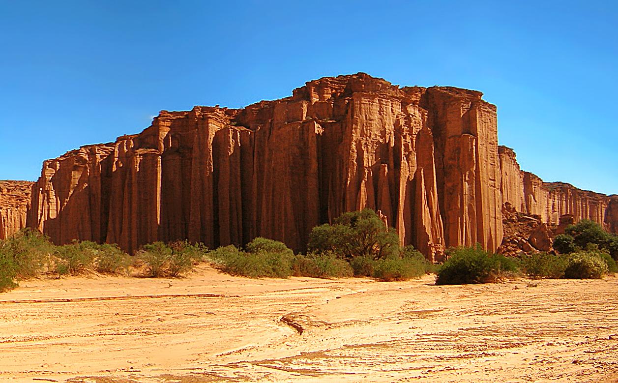
Photo: Gino Lucas T., CC BY-SA 2.5
Talampaya is a red desert canyon in the province of La Rioja, in the dry north-west of Argentina, whose vertical sandstone walls, a hundred and fifty metres high, are among the great sights of the country, and it forms, with the neighbouring provincial park of Ischigualasto, the Valley of the Moon, a single World Heritage Site. It is remote from the usual tourist routes: the nearest base is the small town of Villa Union, sixty kilometres to the north, which has hotels and cabins, and the provincial capital, La Rioja, with an airport, lies about 215 kilometres, three hours by road, to the east; many visitors come on a circuit from San Juan or La Rioja that takes in both parks in two days, Ischigualasto being about an hour and a half to the south. The park cannot be explored independently. One drives to the visitor centre, beside the main road, where the national park entrance fee is paid, and where there are a restaurant, an exhibition and a short free trail with life-size models of Triassic animals, and from there all visits are made on guided excursions in the authorised vehicles of the concession holder, tickets for which are sold on the spot or online and sell out in the holidays.
The standard excursion into the Talampaya canyon, of about two and a half hours, in a minibus or an open-topped truck, drives up the dry bed of the river between the walls, with four stops, at a group of petroglyphs, at a patch of native woodland called the botanical garden, where the guide demonstrates the echo in a great semicircular recess known as the chimney, at the wall called the Gothic cathedral, and at the pinnacle of the Monk; a longer version continues to the rock formations of Shimpa. A separate entrance, a few kilometres along the road, run by a local cooperative, gives access by four-wheel-drive truck to the Arco Iris canyon and the Ciudad Perdida, the lost city, a labyrinth of eroded rock. Guided walks and bicycle rides in the canyon, and excursions by the light of the full moon, are also offered.
Talampaya was made a provincial reserve in 1975 and a national park in 1997, covering about 2,150 square kilometres, and in 2000 it was inscribed, with Ischigualasto, as a World Heritage Site, because the two contiguous parks contain the most complete continental fossil record known from the Triassic period, the forty-five million years, from about 250 to 200 million years ago, during which the dinosaurs and the first mammals appeared. The rocks of the basin were laid down through the whole of that time by rivers, lakes and swamps, in a rift valley that was then opening as the supercontinent of Pangaea began to pull apart, layer upon layer to a thickness of several kilometres, and they have preserved an unbroken sequence of the plants and animals that lived there. Ischigualasto has yielded the later part of the story, with some of the oldest known dinosaurs, among them Eoraptor and Herrerasaurus; Talampaya's strata are the older, from the beginning of the period, and in them was found, in the 1960s, Lagosuchus talampayensis, a slender, long-legged reptile the size of a hare, which is regarded as a very close relative of the ancestors of the dinosaurs, together with the remains of early turtles and of the mammal-like reptiles that then dominated the land. The scenery is the work of a later age.
When the Andes rose, the beds were uplifted and tilted, and water and wind, working on the soft red sandstones over millions of years, carved the canyon of the Talampaya river, which is nearly always dry, a corridor several kilometres long and at its narrowest some eighty metres wide, between walls of a deep, rust red, perfectly vertical and fluted like organ pipes, on whose ledges condors nest. The name is said to mean the dry river of the tala tree in the language of the Diaguita. People lived here from about two and a half thousand years ago, and left, on fallen blocks at the mouth of the canyon and elsewhere, a large number of petroglyphs, pecked into the dark desert varnish of the rock: guanacos, rheas, pumas, human figures with headdresses, footprints, and geometric designs, with mortars hollowed in the rock for grinding the pods of the algarrobo. The vegetation is that of the Monte desert, a sparse scrub of creosote-like jarilla, cacti and saltbush, with gallery woods of algarrobo, chanar and tala trees where there is water below ground, some of the algarrobos in the canyon being several centuries old. Guanacos, maras, the Patagonian hares that run like small antelopes, grey foxes, which hang about the stops in the hope of food, armadillos, rheas and the Andean condor are commonly seen.
The park is open all year, excursions leaving throughout the day, with the last in mid-afternoon. The best seasons are autumn, from March to May, and spring, from August to November, when the days are warm, 20 to 28 degrees, and the air clear; winter, from June to August, is dry and sunny, mild at midday and very cold at night and in the early morning, below freezing, and July, the Argentine winter holiday, is busy. Summer, from December to February, is extremely hot, above 40 degrees, and it is then that the year's scanty rain falls, in sudden thunderstorms that send flash floods down the canyon and cause excursions to be suspended, sometimes for days.
A hot, dry, dust-laden wind from the Andes, the zonda, can blow between May and October. The walls glow most intensely in the first excursion of the morning and the last of the afternoon. Bring a hat, sunscreen, water and a warm layer, and book ahead for Easter and July. Allow half a day for the canyon, a full day with the lost city. Ischigualasto is an hour and a half away, and the Cuesta de Miranda road to Chilecito an hour north.
314 km away
Sierra de las Quijadas is a park of red sandstone canyons in the dry north-west of the province of San Luis, in central…
1 ticket or tour
325 km away
Villavicencio is a private nature reserve in the dry foothills of the Andes, its entrance about forty-five kilometres,…
4 tickets & tours
No online tour for Talampaya National Park is listed on GetYourGuide; entry, where it is charged, is paid at the gate or through the park authority. Nearby parks with bookable tours are listed on this page.
The park is open all year, excursions leaving throughout the day, with the last in mid-afternoon.
Allow half a day for the canyon, a full day with the lost city.
Talampaya National Park covers 2 138 km².
Talampaya National Park was established in 1997.
Talampaya National Park is in Argentina. The map on this page shows the exact spot.
Argentina
Los Glaciares is the park of the Perito Moreno glacier and the Fitz Roy massif in Argentine Patagonia, and it is…
52 tickets & tours
Argentina
The park is twelve kilometres west of Ushuaia and is the standard half-day excursion for everyone passing through the…
36 tickets & tours
Argentina
Iguazú National Park is the Argentine side of the falls, twenty minutes from Puerto Iguazú, and it is entered with a…
11 tickets & tours
Argentina
Nahuel Huapi is the lake-and-mountain park of northern Patagonia, and the city of San Carlos de Bariloche, two hours by…
5 tickets & tours
Argentina
Villavicencio is a private nature reserve in the dry foothills of the Andes, its entrance about forty-five kilometres,…
4 tickets & tours
Argentina
Ansenuza is one of the newest national parks of Argentina and protects Mar Chiquita, an immense salt lake in the…
1 ticket or tour