
Fiordland National Park
New Zealand
Fiordland covers the whole south-western corner of the South Island of New Zealand, the largest national park in the…
81 tickets & tours
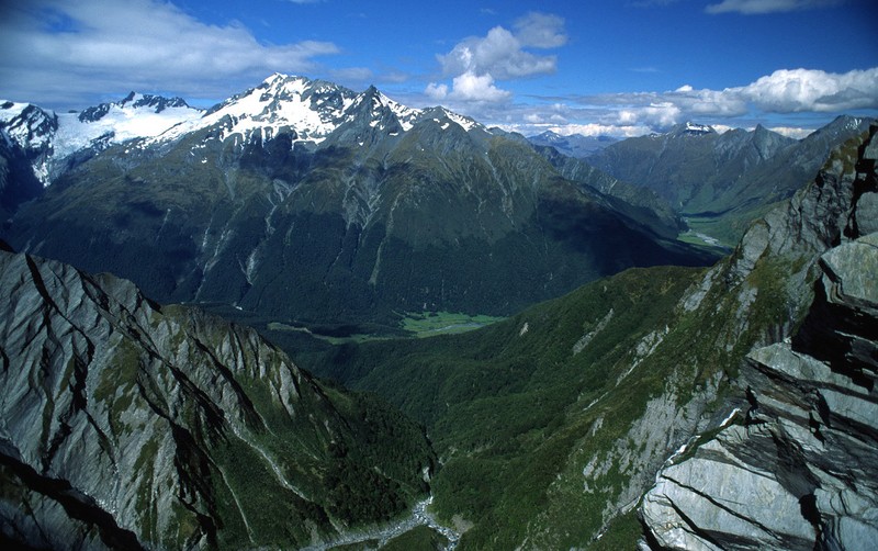
Mount Aspiring National Park covers the southern end of the Southern Alps, in the South Island of New Zealand, between the Haast Pass road in the north and Fiordland in the south, and it is entered from three directions, each with its own base and its own character. From the lakeside resort of Wanaka, an hour over the hills from Queenstown and its airport, a road runs fifty-four kilometres up the Matukituki valley, the last thirty of them unsealed, with several fords that become impassable after rain, to the Raspberry Creek car park, the start of the most popular day walk in the park, the Rob Roy Glacier track: ten kilometres and three to four hours return, across a swing bridge and up through beech forest to an open basin directly beneath a hanging glacier, from which waterfalls and, now and then, blocks of ice fall.
The flat valley walk continues to Aspiring hut, and, for the experienced, to French Ridge or over the Cascade Saddle. From Glenorchy, forty-five minutes from Queenstown at the head of Lake Wakatipu, roads lead to the start of the Routeburn Track, a Great Walk of thirty-two kilometres and two to three days, shared with Fiordland, whose huts must be booked months in advance and whose first section makes a fine day walk, and to the Rees and Dart valleys, a circuit of four to five days; jet boats and inflatable canoes ply the Dart river. From the Haast Pass highway, near Makarora, short paths lead to the Blue Pools, to Fantail and Thunder Creek falls, and a combined flight, walk and jet-boat trip visits the Siberia valley. Guided canyoning trips from Queenstown and Wanaka, abseiling and sliding down stream gorges in wetsuits, are a speciality. There is no entrance fee.
Live dates and prices from GetYourGuide. Free cancellation on most tickets.
The park was established in 1964, the tenth in New Zealand, and with later additions, including the remote Landsborough valley, covers about 3,560 square kilometres; since 1990 it has been part of Te Wahipounamu, the World Heritage area of the south-west of the South Island, the name meaning the place of greenstone, for it was up these valleys and over these passes that Maori parties travelled to the sources of pounamu, the nephrite jade that was their most precious material. Mount Aspiring, called Tititea, the glistening peak, 3,033 metres, is the only summit over three thousand metres in the country outside the Aoraki Mount Cook region, a sharp, ice-sheathed pyramid often compared to the Matterhorn, which is hidden from the roads and seen only by those who walk or fly; it was first climbed in 1909. More than a hundred glaciers, of which the Bonar, Volta and Therma, round Aspiring, are the largest, descend from the main divide, all of them shrinking, and the ice of the past carved the long, flat-floored, steep-walled valleys, the hanging side valleys with their waterfalls, and the lake basins that give the region its form. The rock is schist, grey and glittering with mica, which breaks down into the silt that makes the rivers milky blue and their beds wide and braided.
The main divide catches the westerly weather, so that the western valleys receive six metres or more of rain a year and are filled with dense, mossy rainforest of silver beech, rimu and tree ferns, while the eastern valleys, in the rain shadow, are open and grassy on their floors, with red and mountain beech on the slopes; above the bushline, at about a thousand metres, lie snow tussock, herb fields with the giant white buttercup known as the Mount Cook lily, mountain daisies and gentians, all white or pale, since the native pollinators are moths and flies that do not see colour. The kea, the inquisitive mountain parrot that dismantles boots and car trimmings, the tiny rock wren, the blue duck, the yellowhead, the South Island robin, the rifleman, the kaka and the long-tailed bat, one of New Zealand's only two native land mammals, live here, all under pressure from introduced stoats, rats and possums, against which intensive trapping is carried on in the Dart, Routeburn, Matukituki and Makarora valleys. Red deer, chamois and tahr, introduced for sport, are hunted. The landscapes around Glenorchy and Paradise served as Isengard and Lothlorien in the Lord of the Rings films. In 2013 the government rejected a private proposal to bore a tunnel for buses under the park to shorten the journey to Milford Sound.
The park is open all year, but the season for the tracks is from late October or November to April. December to February are the warmest months, with long days, alpine flowers and the most walkers; March and April are often the most settled, with cool, clear weather and, round Wanaka and Glenorchy, brilliant autumn colour. The weather can turn severe in any month, with snow to low levels even in summer, and heavy rain, which falls frequently, raises the unbridged rivers and side streams within hours;
more trampers die in New Zealand by drowning in river crossings than in any other way, and the rule is to wait. In winter and spring the upper part of the Rob Roy track and the alpine sections of the Routeburn are exposed to avalanches. Sandflies are a torment in the valleys, so bring repellent, with warm and waterproof clothing whatever the forecast, and check the Matukituki road conditions in Wanaka. Allow a day for Rob Roy, three for the Routeburn. Wanaka, Queenstown and Glenorchy are the bases, the west coast glaciers three hours beyond Haast.
Yes. GetYourGuide lists one ticket or tour for Mount Aspiring National Park, with live dates and prices and free cancellation on most of them.
There is no entrance fee.
There is no entrance fee.
The park is open all year, but the season for the tracks is from late October or November to April.
Allow a day for Rob Roy, three for the Routeburn.
Mount Aspiring National Park covers 3 562 km².
Mount Aspiring National Park was established in 1964.
Mount Aspiring National Park is in New Zealand. The map on this page shows the exact spot.
New Zealand
Fiordland covers the whole south-western corner of the South Island of New Zealand, the largest national park in the…
81 tickets & tours
New Zealand
Aoraki / Mount Cook National Park contains the highest mountains and the longest glaciers of New Zealand, in the centre…
68 tickets & tours
New Zealand
Westland Tai Poutini National Park lies on the wet western side of the Southern Alps, in the South Island of New…
49 tickets & tours
New Zealand
Abel Tasman is the coastal park at the top of New Zealand's South Island, an hour from Nelson to the gateway…
16 tickets & tours
New Zealand
Arthur's Pass is the mountain park on the main divide of New Zealand's South Island, two hours from…
13 tickets & tours
New Zealand
Tongariro is the volcanic heart of New Zealand's North Island, four and a half hours'
6 tickets & tours


