Teide National Park
Canary Islands, Spain
Teide is the volcano at the centre of Tenerife and the most visited national park in Spain, and it is reached from…
48 tickets & tours
Volcano Park · Canary Islands · Spain
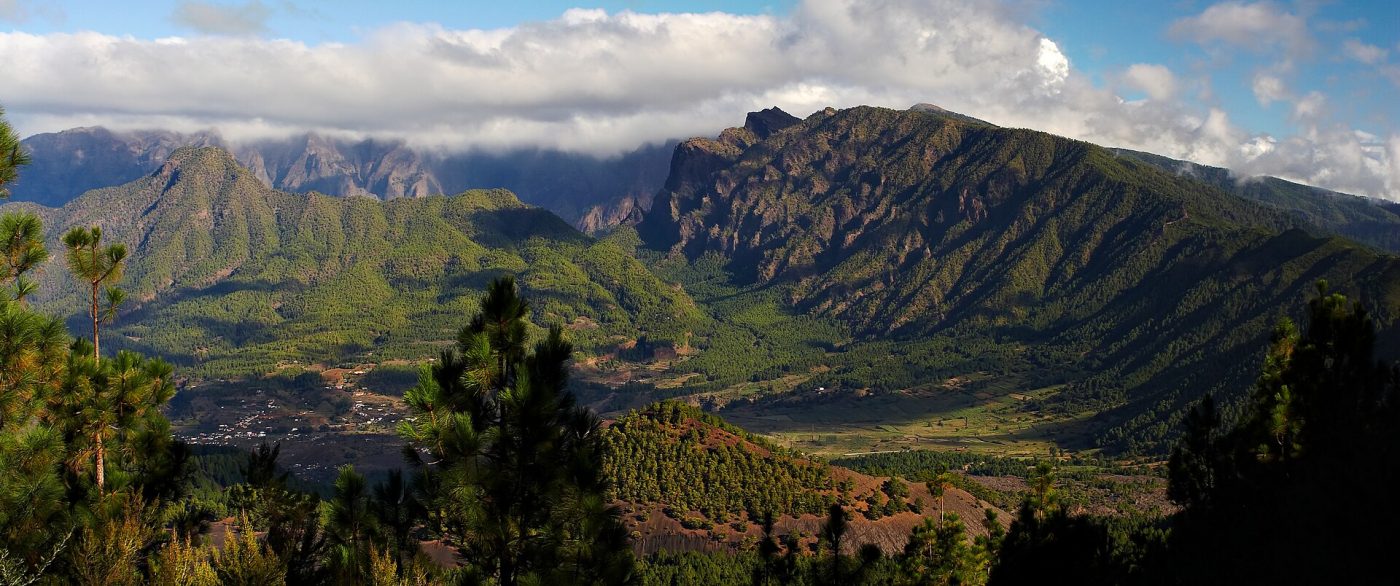
Photo: Michael Apel, CC BY-SA 3.0
The Caldera de Taburiente is an enormous, pine-clad crater-like depression that occupies the centre of the northern half of La Palma, the north-westernmost of the Canary Islands, which is reached by air from Tenerife, Gran Canaria and Madrid and by direct flights from several European countries. It is a walkers' park: no road crosses it, and the interior can be seen only on foot. Entry is free, but there are three access points, each with its own rules. La Cumbrecita, a saddle on the southern rim at 1,300 metres, is reached by a road from the visitor centre at El Paso, on the island's main road; its small car park is controlled, and a free reservation for a time slot must be made online or at the visitor centre for any arrival before mid-afternoon. From it, a nearly level path of half an hour leads to the viewpoints of Lomo de las Chozas and Los Roques, which give the easiest view into the interior.
The classic full-day walk starts instead from Los Brecitos, on the western rim: walkers leave their cars in the bed of the Barranco de las Angustias, below the town of Los Llanos de Aridane, take one of the shared four-wheel-drive taxis that wait there up a long forest track to Los Brecitos, and then walk back, some fourteen kilometres and six hours, almost all downhill, through pine forest to the camping zone and ranger hut at the Playa de Taburiente, a broad pebbly stream bed in the heart of the caldera, and then down the gorge of the Angustias, fording the stream repeatedly, with a short detour to the Cascada de Colores. The third access is the rim itself, reached by a long mountain road from Santa Cruz to the Roque de los Muchachos. Guided hikes with transport save the logistics. Camping requires a permit, obtained in advance.
Live dates and prices from GetYourGuide. Free cancellation on most tickets.
The Caldera was declared a national park in 1954, one of the oldest in Spain, and covers about forty-seven square kilometres. It is a vast amphitheatre some eight kilometres across, enclosed by a horseshoe of cliffs which drop as much as two thousand metres from the rim, crowned by the Roque de los Muchachos, 2,426 metres, the highest point of the island, to a floor that lies at only four to nine hundred metres, open to the sea on the south-west by the single narrow gorge of the Angustias, the ravine of anguish. It holds a curious place in the history of science: the German geologist Leopold von Buch, who visited it in 1815, took the local word caldera, a cauldron, and introduced it into geology for large volcanic depressions, yet this type specimen is not a caldera in the modern sense at all, having been formed not by an explosion or the collapse of a magma chamber but by a gigantic landslide of the flank of an old shield volcano, some half a million years ago, enlarged ever since by the erosion of torrents. In its walls the whole anatomy of an oceanic island is laid bare, down to the pillow lavas erupted on the sea floor before the island existed, now lifted a thousand metres. The slopes are covered by forests of the Canary pine, a tree found only in this archipelago, with needles in threes and a thick, corky bark which allows it to survive forest fires and to sprout again from the blackened trunk.
Water is the caldera's other treasure. It is the only place in the Canaries where streams run all year, fed by dozens of springs and by galleries bored into the rock, and the water, carried out through canals to the banana plantations of the Aridane valley, has belonged since the sixteenth century to an association of landowners, the heirs of the estates of Argual and Tazacorte, who also owned the land of the park itself. At the Cascada de Colores, iron-rich spring water has stained a small dam wall orange, yellow and green. In the middle of the caldera rises the Roque de Idafe, a slender pillar of rock which the island's original people, the Benahoaritas, held sacred, believing that it supported the sky, and to which they brought offerings of entrails lest it fall. The caldera, which they called Aceró, the strong place, was the last part of La Palma to resist the Castilian conquest: its chief Tanausu held the passes through the winter of 1492 to 1493 until Alonso Fernandez de Lugo lured him out to a parley and seized him, and he starved himself to death on the ship carrying him to Spain. On the rim stands one of the world's great astronomical observatories, including the largest optical telescope in existence, with a mirror of 10.4 metres.
The park is open all year, and the climate is mild in every season, though the rim may be under snow and ice in winter and the floor of the caldera very hot in summer. Spring and autumn are the best seasons for the long walk. The one serious danger is water: after heavy rain, mainly between November and March, the stream in the Barranco de las Angustias can rise within minutes, and walkers have been drowned, so that the route is closed when rain is forecast and the rangers' advice must be followed;
in summer and autumn the park may be closed in periods of extreme fire risk. Start the Los Brecitos descent early, since the taxis run chiefly in the morning, and carry at least two litres of water, food, a hat and footwear that can get wet. Allow a full day, and another for the rim. El Paso and Los Llanos are the nearest towns, the Roque de los Muchachos an hour and a half from Santa Cruz, and the lava fields of the 2021 eruption lie just to the south.
Yes. GetYourGuide lists one ticket or tour for Caldera de Taburiente National Park, with live dates and prices and free cancellation on most of them.
Entry is free, but there are three access points, each with its own rules.
The park is open all year, and the climate is mild in every season, though the rim may be under snow and ice in winter and the floor of the caldera very hot in summer.
Allow a full day, and another for the rim.
Caldera de Taburiente National Park covers 46.9 km².
Caldera de Taburiente National Park was established in 1954.
Caldera de Taburiente National Park is in Canary Islands, Spain. The map on this page shows the exact spot.
Canary Islands, Spain
Teide is the volcano at the centre of Tenerife and the most visited national park in Spain, and it is reached from…
48 tickets & tours
Canary Islands, Spain
Timanfaya is the lava field of south-western Lanzarote, half an hour from the island's resorts, and it is a park…
13 tickets & tours
Canary Islands, Spain
The Corralejo dunes lie immediately south of the resort town of Corralejo at the northern tip of Fuerteventura in the…
7 tickets & tours
Canary Islands, Spain
Jandía is the mountainous peninsula that forms the south-western tail of Fuerteventura in the Canary Islands, joined to…
4 tickets & tours
Canary Islands, Spain
Garajonay occupies the summit plateau of La Gomera, the small, round, deeply ravined island that lies within sight of…
1 ticket or tour
Canary Islands, Spain
The Corona Forestal, the forest crown, is the great ring of pine woods that encircles the high central part of…
No online ticket