Folgefonna National Park
66 km away
Folgefonna is the ice cap on the peninsula between the Hardangerfjord and its branch the Sørfjord, in western Norway,…
3 tickets & tours
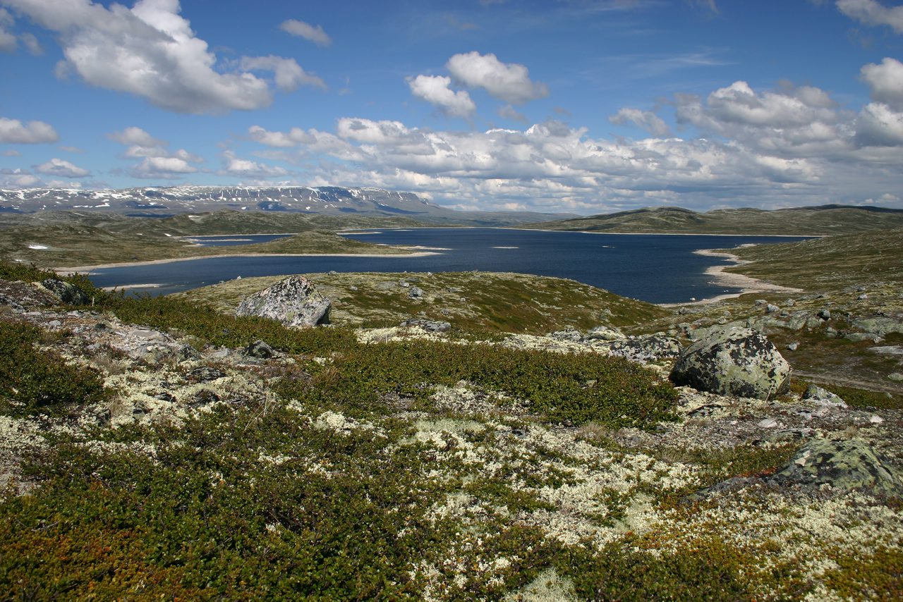
Photo: Smtunli, Svein-Magne Tunli - http://www.tunliweb.no/SM/Engl, CC BY-SA 3.0
The Hardangervidda is the largest mountain plateau in northern Europe, a vast, treeless upland of rock, heather, lakes and rivers in the south of Norway, between Oslo and Bergen, and its national park, the biggest in mainland Norway, is the classic country for walking from hut to hut in summer and for long ski tours in winter. It is unusually easy to reach. The Bergen railway, one of the great train journeys of the world, runs along its northern edge, stopping at Geilo, Ustaoset, Haugastol and Finse, at 1,222 metres the highest station on the line, from all of which marked paths lead directly on to the plateau; and national road 7, a designated scenic route, crosses it for some seventy kilometres between Haugastol and Eidfjord, above the tree line, passing the Voringsfossen waterfall on its western descent, so that even those who never leave the car see something of it.
In the south, the road from Rjukan climbs to the edge of the plateau, and the Krossobanen cable car, built in 1928, carries walkers up from that town. Entry is free and there are no gates. The Norwegian Trekking Association maintains across the plateau a network of paths marked with red letter Ts, with bridges over the larger rivers, and some forty cabins, a day's walk apart, some staffed lodges serving dinner, others self-service huts stocked with food and opened with the association's key, so that one can walk for a week with a light pack; a traverse from Finse or Haugastol south to Haukeliseter takes seven to eight days. Day walkers choose the path from Kinsarvik up the Husedalen, past four great waterfalls, the walk from the road to the plateau's dark landmark, Harteigen, or, above all, the famous hike to Trolltunga, the rock tongue above Lake Ringedal near Odda, a strenuous ten to twelve hours which lies at the park's western margin. The nature centre at Eidfjord explains the plateau well.
Live prices from GetYourGuide for tours whose route includes this park. Free cancellation on most of them.
The national park was established in 1981 and covers about 3,422 square kilometres, less than half of the plateau as a whole, which extends to some eight thousand. The vidda is a peneplain, the worn-down stump of mountains that were ancient before the dinosaurs, planed almost flat, lifted bodily, and then scraped clean by the ice sheets, which left a gently undulating surface at 1,100 to 1,400 metres, strewn with boulders and dotted with thousands of lakes and tarns, drained by broad, shallow rivers. Its eastern part is open, rolling and relatively dry; its western part is higher, wetter and more rugged, with snowfields that last all summer, and ends abruptly in a wall a thousand metres high above the branches of the Hardangerfjord, over which the rivers fall in some of the highest waterfalls in the country, the Voringsfossen, with a drop of 182 metres, the best known. The only real summit is Harteigen, 1,690 metres, a flat-topped tower of dark rock visible from half the plateau, which served travellers as a landmark for centuries, and on its north-western edge lies the Hardangerjokulen, an ice cap of some seventy square kilometres, on which the battle scenes on the ice planet in a celebrated science fiction film of 1980 were shot, from a base at Finse.
The plateau is, in climate and vegetation, a piece of the Arctic displaced far to the south, and many arctic plants and animals, the arctic fox, the snowy owl, the snow bunting and the dotterel among them, have here their southernmost outpost in Europe. It is the home of the largest herd of wild reindeer in Europe, between six and ten thousand animals according to the year, the descendants of the herds that followed the retreating ice ten thousand years ago, which migrate across it from the winter pastures of lichen in the east to the calving grounds and summer grazing in the west; they are extremely wary, keeping a kilometre or more from people, and their need for undisturbed space governs the routing of paths and the closure of huts, and an outbreak of a fatal wasting disease found among them in 2020 is a cause of great anxiety. Men have hunted these reindeer since the Stone Age, and the plateau is covered with their traces, hundreds of pitfall traps dug into the ground, stone hunting blinds and the sites of seasonal camps; across it run the old cairned tracks, the Nordmannsslepene, by which farmers and traders from the western fjords drove their cattle and carried their goods to the markets of the east. In the winter of 1942 to 1943 Norwegian commandos, parachuted on to the plateau, survived for months in its huts on moss and reindeer before destroying the heavy water plant at Vemork, near Rjukan, on which the German atomic programme depended.
The plateau is open all year, but it has two distinct seasons. The summer walking season is short, from about the beginning of July to the middle of September, when the staffed lodges are open and the bridges are in place; before July the snow is still deep and the rivers dangerous with meltwater. July and early August are the mildest weeks, 10 to 15 degrees by day, with mosquitoes near the lakes; late August and September bring frost, the reds and yellows of autumn, and the reindeer hunt. Road 7 across the plateau is kept open in winter but is frequently closed or restricted to convoys in storms.
From late February to early May the vidda is one of the great arenas of Nordic ski touring, the lodges opening for Easter, which Norwegians traditionally spend here. The weather is severe and changes without warning at any season, with gales, fog and snow in midsummer, and the plateau offers no shelter, so that a map, compass, windproof and warm clothing and spare food are essential. Allow a day for a taste, a week for a crossing. Eidfjord and the Hardangerfjord lie to the west, Geilo and Rjukan to the east.
66 km away
Folgefonna is the ice cap on the peninsula between the Hardangerfjord and its branch the Sørfjord, in western Norway,…
3 tickets & tours
159 km away
Jotunheimen, the home of the giants, is the highest mountain region of northern Europe, in the centre of southern…
1 ticket or tour
265 km away
Dovrefjell is the high mountain plateau that separates southern Norway from the Trondheim region, and it is unusually…
1 ticket or tour
Yes. GetYourGuide sells tickets and guided tours whose route includes Hardangervidda National Park; live prices are shown on this page.
Entry is free and there are no gates.
The plateau is open all year, but it has two distinct seasons.
Allow a day for a taste, a week for a crossing.
Hardangervidda National Park covers 3 422 km².
Hardangervidda National Park was established in 1981.
Hardangervidda National Park is in Norway. The map on this page shows the exact spot.
Norway
Folgefonna is the ice cap on the peninsula between the Hardangerfjord and its branch the Sørfjord, in western Norway,…
3 tickets & tours
Norway
Dovrefjell is the high mountain plateau that separates southern Norway from the Trondheim region, and it is unusually…
1 ticket or tour
Norway
Jotunheimen, the home of the giants, is the highest mountain region of northern Europe, in the centre of southern…
1 ticket or tour
Norway
Jostedalsbreen is the largest glacier on the mainland of Europe, an ice cap more than sixty kilometres long lying on…
No online ticket
Norway
Rondane is a compact massif of high, rounded, stony mountains in the interior of southern Norway, between the long…
No online ticket